Winter Watch
❄️ Everything you need to know about the latest winter weather news and lifestyle updates.
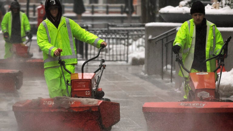
A nor’easter is set to descend on New England on Tuesday, with meteorologists expecting Boston and surrounding areas could see up to a foot of snow.
While maps differ slightly on just how far south the storm is going to be, it is expected to drastically lower visibility in the morning through early afternoon, and cause travel disruptions, power outages, and school closures.
Boston Mayor Michelle Wu announced that the city’s public schools will be closed Tuesday and urged all residents to stay at home. Wu declared a snow emergency to begin at 10 p.m. Monday.
Snowfall is expected to start in the early morning, falling at a rate of 1 to 3 inches an hour. Meteorologist Dave Epstein predicts Boston, central Massachusetts, northern Rhode Island and Connecticut could get at least 8 to 10 inches of snow — possibly up to a foot in spots — with southeastern Massachusetts and Rhode Island getting between 3 to 6 inches, and the Cape may see 4 to 8 inches.
A winter storm warning has been issued for Tuesday for Greater Boston and most of Massachusetts, excluding northwest and southeast portions of the state and the Cape. Northern Rhode Island and Connecticut are also included in the warning. Southern New Hampshire and Vermont are under a winter storm watch Monday night into Tuesday.
The National Weather Service urged residents to take caution between 8 a.m. and 3 p.m. on Tuesday, when the storm will have the “highest impact.”
“Travel during this period will be hazardous and is not recommended,” the agency said over X, formerly known as Twitter.
As the snow blankets the city and surrounding areas, we want to see firsthand how it is affecting you, your neighborhood, and your town.
Send us photos of how much snow you got, what winter activities you’re participating in (bonus points if you go sledding or cross country skiing), pets enjoying the snowfall, what your commute looks like if you’re out on the road, and any creative snapshots.
Send us your photos by filling out the survey below or emailing us at [email protected], and we may share them in an upcoming article on Boston.com. Share your Instagram handle and we may also tag your photos.
❄️ Everything you need to know about the latest winter weather news and lifestyle updates.


Be civil. Be kind.
Read our full community guidelines.